
The Tintern Secret Medieval Tunnel story. A reply
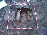
One of a number of cut and cover drains excavated within Tintern Abby Precinct
On the 5th of March 2021, a colleague of mine from another local archaeological company telephoned, requesting the contact details for one of my clients in Tintern, with whom I have been working since mid-2007. An acquaintance of his had been contacted by an American with an interest in Tintern Wireworks. In the first instance, I suggested they contact me as I was not able to divulge personal contact details without prior permission. As yet there has been no reply.
Since 2007, I have worked commercially on various sites within the Tintern area; however, for the last 10 years, I have managed a site adjacent to Tintern Furnace on a voluntary, non-commercial basis.
On Sunday 7th, one of my research staff sent me a link to the BBC Wales story entitled: ‘Tintern secret medieval tunnel found by accident’ [https://www.bbc.co.uk/news/uk-wales-56281726]. Interesting story but apart from the accidental nature of its discovery and its tunnel-like structure; a very misleading account and interpretation, to say the least. My first reaction was to ignore it, but since then further publication sources have hit the internet with variations on the same sensationalist theme. I noted one in particular from the Smithsonian Magazine; possibly the ‘American’ alluded to above.
Addressing the errors first: The original BBC Wales Online story suggested the discovery ‘as recent’, whereas it actually happened on 5th October 2020. The tunnel is not medieval, but a mid-18th /early-19th drain; part of the industrial wire working industry, which was located in the valley and clearly listed on 19th-century Ordnance Survey maps as Middle Wireworks. ‘Secret’ would suggest purposefully hidden, but this drain was just forgotten with disuse as its industry closed at the start of the 20th century, after almost three and a half centuries in operation. As to the association with Tintern Abbey; it is known archaeologically that
brass production was undertaken there in the 15th century, (Courtney, 22 1982) and there were possibly watermills associated with the Abbey, located on the Angidy, (Paar & Tucker, 3. 1975). However, I excavated some medieval drains within the Abbey precinct in 2017: (APAC.Ltd WB/AT/16), they were very much smaller, also forgotten rather than secret, but definitely medieval.
https://s3-eu-west-1.amazonaws.com/cdn.webfactore.co.uk/sr_1334065_preview.jpg?1616244472
In 1536, the dissolution of Tintern Abbey would have had a negative, effect on the area and those dependent on it for work shelter and sustenance. Thirty years later, in the reign of Elizabeth I, the Angidy Valley location offered a site with a local experienced workforce, (metalworking), pre-existing water-powered mill structures, ample fuel, raw materials, minerals and transportation links. An ideal location for the establishment of a company set up to improve ironworking using waterpower and charcoal-fired furnaces.
In 1566, in an effort to make Britain less reliant on foreign sources for armour and munitions, Elizabeth I granted Letters Patent to erect ‘batterys’ at Tintern for working Iron; to The Company of Mineral and Battery Works, (Macdonald, M, B, 1961). -The battery in this context refers to a water-powered array of hammers for crushing mineral or shaping hot iron, and not the modern electric power storage devices; although, it is an interesting coincidence.- A little later, experimentation in iron wire production for carding combs required by the burgeoning wool industry would later lead to 3 wire works being built to deal with the demand. The ‘secret medieval tunnel’: was part of the middle wire works, see Parr & Tuckers’ 1821 schematic plan taken from the 1763 Aram survey.
I discovered a section of the Middle wireworks water management system, close to the ‘secret tunnel’ in 2012, APAC. Ltd WB/CCT/12.
To summarise: 1566 is not the medieval period, and the wireworks to which the ‘secret tunnel’ belong were recorded on a 1763 survey, (ARAM, J., 1763), and later lease surveys and ordnance survey maps until 1886.
I have spoken with the owners of the associated site I manage, and we decided to offer a more rational explanation of the new discovery based on known facts; consequently, we have to break the story of the actual discoveries, on-going at Tintern, as their context provides archaeological comparisons. All the fully illustrated APAC. Ltd reports mentioned in this account can be accessed online from Scribd or requested from Royal Commission on Ancient and Historical Monuments Wales (RCAHMW), Glamorgan Gwent Archaeological Trust Historical Environmental Record (GGAT) HER, or Gwent Archives.
None of the structures described, except for the Scheduled Monument, Tintern Furnace Site, are open to public access and all excavated structures to date have been recorded and backfilled for preservation.
The Scheduled Site of Tintern Furnace in 2007
In 2007, my first clients in the Angidy Valley were a local group of entrepreneurs who proposed to install a small hydroelectric system, utilising the existing dams and leats from the old industrial ironworks: TAP (Tintern, Angidy, Hydroelectric Project). This first contract proposed some test pits positioned along with the known leat system, but this planning proposal was
deferred by (GGAT), until a full Desk Base Assessment of that part of the valley to be affected by the proposal, had been completed. The Desk-Based Assessment: APAC. Ltd DBA/TAP/08, revealed a large number of previously unrecorded sites; not Secret relating to the ironworks industry in the valley.
However, the real value of the research proved to be the cartographic data collected, which was to become invaluable.
The second project was for the AONB, APAC. Ltd. WB04/AONB1/07, who took on the task of draining and clearing the Tintern Furnace site, Scheduled Monument, MM197. The Furnace site had been cleared and excavated in 1979-1981 as part of a Manpower Sevices Scheme, (Pickin J. 1982).
Prior to the earlier clearance work, the site was little known; in fact, a field visit by the Newcomen Society in 1947 failed to find it: (Trans Newcomen Soc 25: 209). John Pickin’s excavations cleared a site that is well worth a visit;
however, the work was plagued at the time and since with flooding, which left areas of archaeological significance inaccessible.
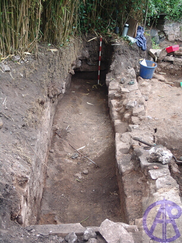
The outfall of the cottage found 2.7m below the ground in the position marked on the 1763 Survey. Shown ar to sections of cut and cover flagstoned removed
The scheduled site is some 8 to 10m from the Angidy River, which runs along its northern edge and separated only by a bank of made-up ground. The ground level of its lower exposed surface the casting floor is slightly lower than the water level of the river, however, contrary to common sense: when the river flooded the site was dry and when the river was low the site used to flood.
A working solution to this anomaly was offered after clearance of the wheel pit and some of the drains, APAC.Ltd WB/AONB3/10.
In a working system, water should flow into the wheel pit over the waterwheel and drain out at the bottom. The current interpretation is that water was draining from the river into the wheel pit because of syphon action presumed to be from a collapsed drain causing a breach to the river, downstream of the wheel pit. The watching brief condition did not allow for this to be further explored.
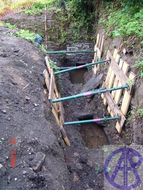
Work on the drainage culvert began over the road from the Scheduled site; in a private garden, which is relatively lower than the Furnace site. John Pickin had noted an outfall further downstream of the garden during the 1979/81 clearance work and had overseen some limited excavation by the owner within the garden. She uncovered and recorded a low building butted to the road, which is a raised causeway at this point. Within the low structure was the first few steps of a stone stairwell before the water level was reached.
In 2007, after a few days of uneventful excavation, I referred the groundworks company to the 1763 survey, and Parr and Tuckers 1821 schematic; consulted for the desk-based assessment, APAC. Ltd. WB04/AONB1/07. By orientating the maps to the road and the low walled structure visible on the
ground, the position of the emergence of the drain was accurately pinpointed and found, some 2.7 below ground.
The wall with the ranging rod is the previously buried low wall structure; marked on the maps as ‘The Cot’ or later The Cottage. The cottage was lime plastered on the outside of the building; therefore, originally stood above ground. The culvert depicted accurately on the 1763 survey and Parr and Tucker's 1821 schematic estate map, was originally open and ran along
the side of the building.
In the picture, the lighter coloured masonry is over the drain and abuts the original ground floor of the cottage. The current road causeway is to the right. The ground fill that was removed had a large amount of late 19th century ceramics.
The tunnel beneath the road from the cottage. At the rear is an addition to the wall in order to support bridging cut and cover flagstones.
The earlier maps to 1821 show a definite kink in the road at this point, and there is a previous, offset course of stone at the base of the adjacent bridge, which shows that it has been moved. The later OS maps from 1879 onwards show the new position of the road abutting ‘The Cot’ and the road cutting the furnace site in half, which is possibly indicative of its failure in the late-19th century when its charcoal-based industry finally failed.
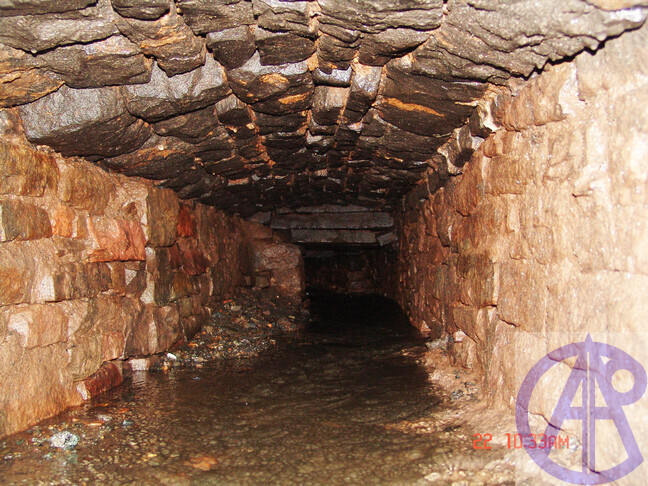
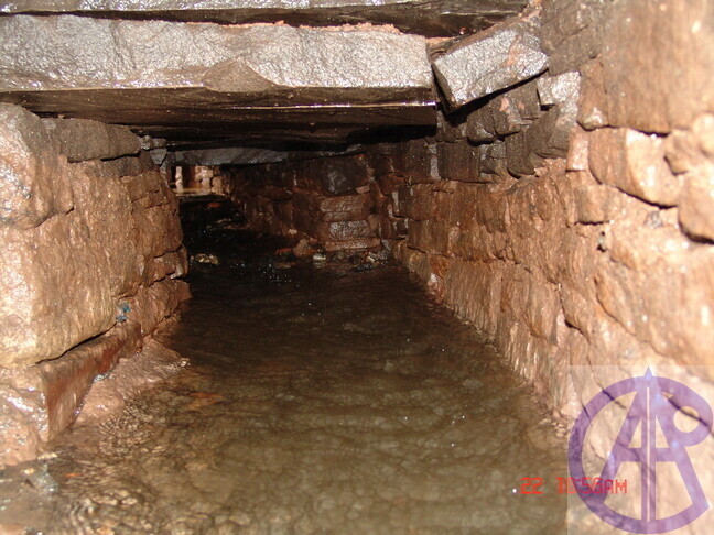
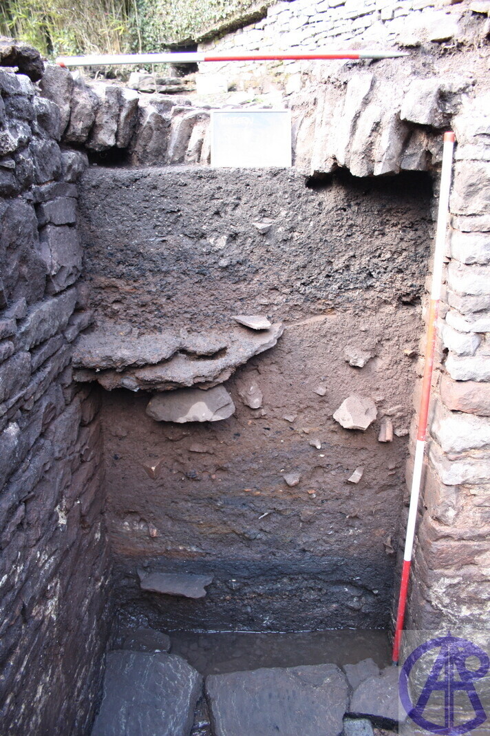
The covered drain beside The Cottage and under the road was therefore constructed post-1821 but pre-1878. The picture to the left shows what the drain looks like under the road, taken from the entrance in the previous picture. The north wall of the Cottage is to the left, it was silted almost and is covered with a masonry arch of rough, squared stone. Identical in size and construction to the reported Secret, Medieval Tunnel
T
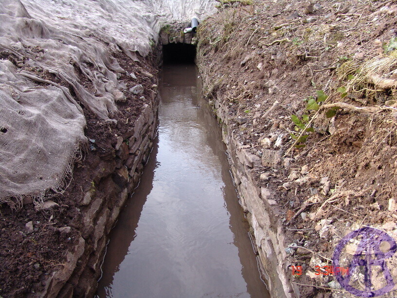
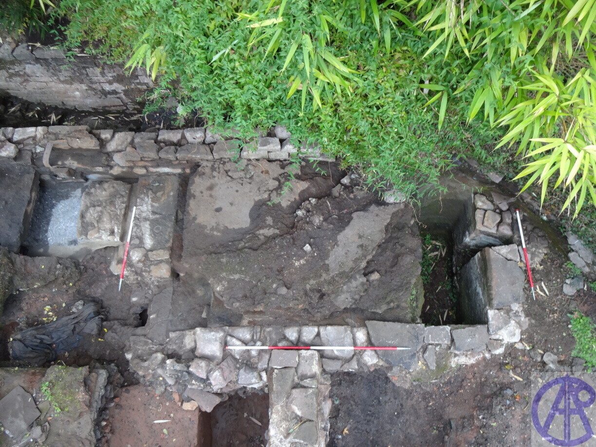
Cut and cover looking downstream from 'the Cot'
The second picture is the same culvert looking downstream where it has a flagstone, cut and cover roof, again identical to the reported
Secret, Medieval Tunnel
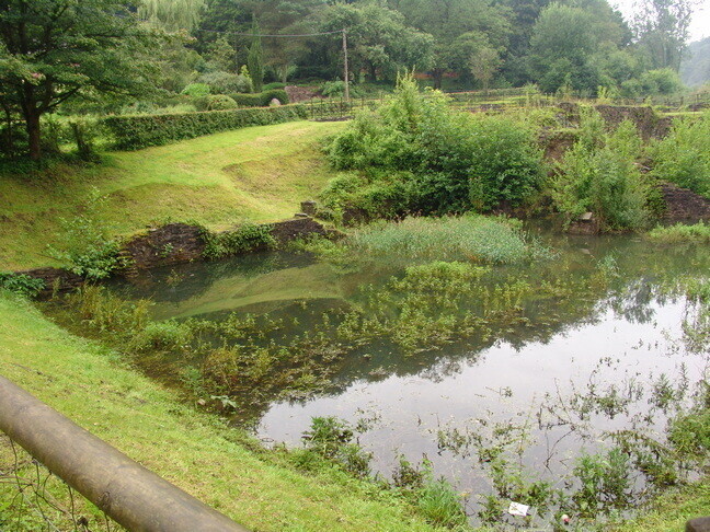
The flagstone covered culvert continued for about 8m before opening out into an 80m open section to the next pond, APAC/JB/10, WB/AONB2/09 & WB/AONB3/10. When discovered it emerged as a resurgence under the bed of a small stream which flowed down towards the pond. This was excavated under private funding, reducing the depth of fill of previously unknown stone-lined channel. A 400mm reduction there produced a 400mm reduction in the furnace site.
Following on from the originally contracted drainage works, certain questions arose that needed answering, which initiated my 10-year voluntary programme at the bottom of the private garden. The work began with a topographic survey, followed by Resistivity, some drone footage and eventually, evaluation, excavation, and 3D recording.
Excavation since 2017 has been diligently undertaken by my privately funded site director Mr S Reames who is currently working on the post-excavation work.
The current working interpretations are:
- An original leat system led to the now private garden area before the current road was constructed, effectively cutting
the original site in half.
- The current wheel pit in the scheduled area is a later phase construction because the water is fed by a raised launder to an overshot wheel at 90 degrees to the rotation of its axle. Not a good design feature, more of a
the best fit solution to an unanticipated problem.
- The original leat led through a building in the garden that we don’t yet understand, to a previously unrecorded wheel pit powering a hammer
the mechanism for which we have both timbers and voids.
- The hammer was fixed to a structure with a heavy build-up of fused iron dust which we interpret as a crushing plant for slag producing bulk product for the glass industry, possibly
bottling in Bristol.
If the interpretation is correct then we have a siltation tank for that process, however, in discussion with other experts in
the field it may be the only known example.
There appears to be a lot of structures buried under the road, which is on a raised causeway at this point with the causeway
engulfing the rear wall of ‘The Cot’. It had a first-floor fireplace and ground floor hearth and flue. When fully excavated
the stub wall extended down to a buried ground floor room with very thick walls, a stairwell, an arched doorway and two
large windows one of which had been blocked in order to construct one of two domed bread ovens.
The heavy construction of the walls, its position next to an open leat or alternatively the river and the accounts of mills
belonging to the Abbey has given us sufficient cause to consider this as one of the missing Mills, associated with the
Abbey.
Private Garden. Excavation of two, parallel, first phase leats from the furnace site. Previously unknown and cut by present road
Previously unknown stone-lined drainage channel from the furnace, under the road, beside 'The Cot'. Open section below 'The Cot' running for 80m, from which 800mm of silt was removed.
Previously unknown wheel-pit fed by the northern parallel leat. Partially excavated to flagstone base at about 2m.
To the west of 'The Cot'; (bottom of photograph), under a paved garden path, a previously unknown flight of stone steps and a cobbled ramp leads down to a stone-lined waterway, purpose unknown. To the top right is an offset stone arch into 'The Cot'
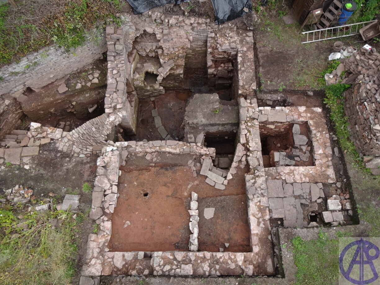
'The Cot' Known as a low stone rectangular wall with 3 steps, (bottom room, top right corner). The excavation uncovered the top centre room with a large hearth, two bread ovens one in a blocked ashlar chamfered door/window, a square window and the arch left to the external stair. The rooms bottom and right are later expansion, probable for the 3 families that are listed living there in 1868.
Stone arched passage to external stairs. The fill which was expertly cleared by Simon Reames shows the fill layers of 'The Cot' former ground floor. The stratigraphy depicts both manual backfill and flood/silt deposits.
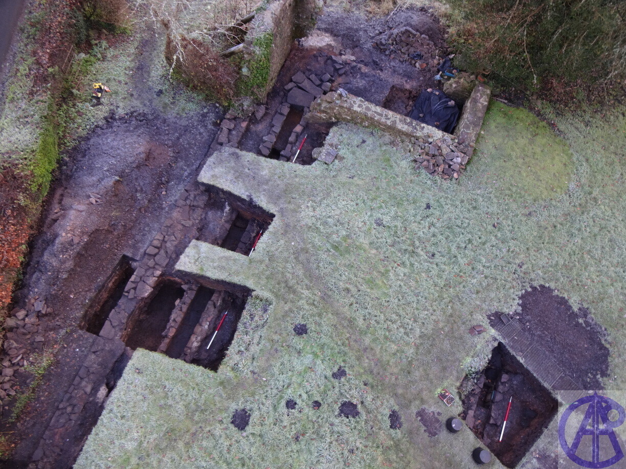
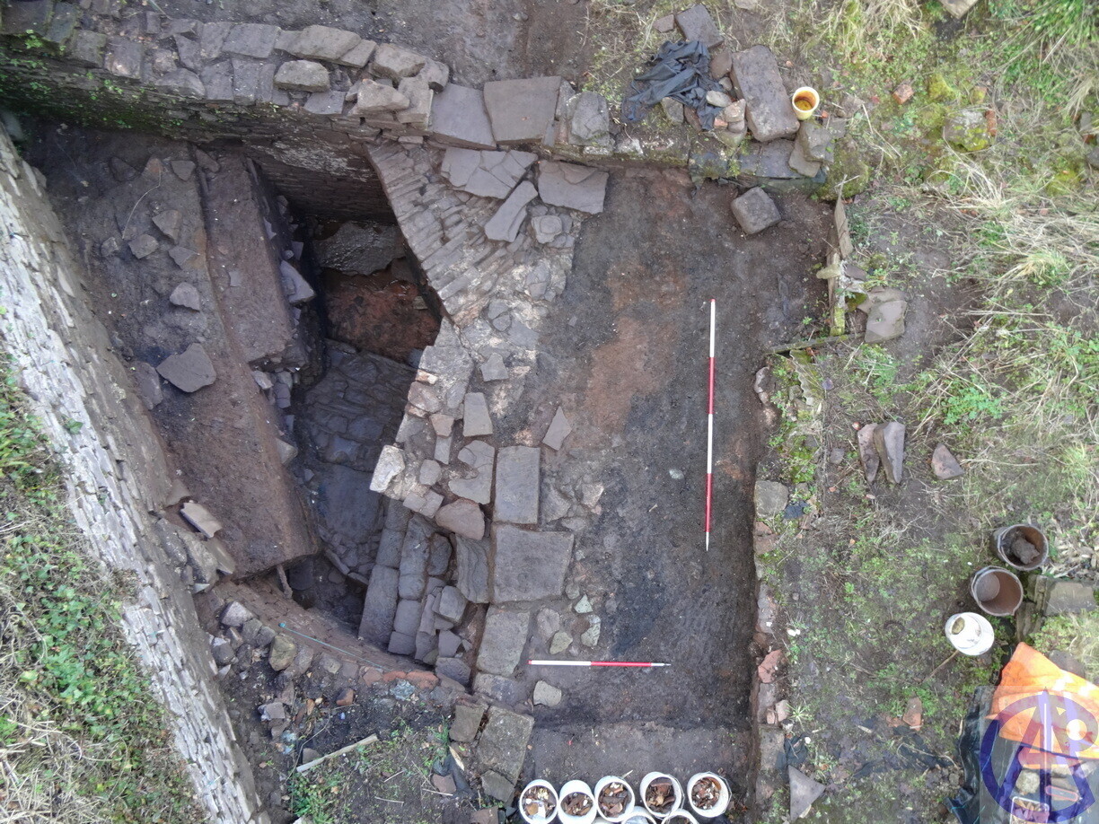
All structures previously unknown and not on any maps after 1763. End of excavation 2019 prior to backfill. Top left wheel-pit, centre left: iron and wood frame voids with stone base for hammer axle, the centre floor of fused iron dust, centre right situation tank with sluice right, bottom left hammer room or forge floor.
References:
APAC. Ltd
DBA/TAP/08 Archaeological Desk-Based Assessment, Proposed Hydro-Electric Project Angidy River, Tintern
WB04/AONB1/07 Archaeological watching brief Angidy Ironworks Tintern
EVTP/TAP/08 Archaeological Evaluation Proposed Pipeline Alongside The Angidy River, Tintern
WB/AONB2/09 Archaeological Watching Brief, Angidy Ironworks Tintern
SC/JBT/09 Archaeological Topographical and Geophysical Survey, Furnace Cottage, Tintern
WB/AONB3/10 Archaeological Watching Brief, Angidy Ironworks, Tintern
WB/AT/16 Archaeological Watching Brief, The Anchor Tintern
BS/TA/14 Archaeological Building Recording Survey Chapel House Culvert. Bridge Tintern
WB/TA/14 Archaeological Watching Brief, Chapel House Culvert. Bridge Tintern
WB/CCT/12 Archaeological Watching Brief, Crown Cottages, Tintern.
Aram J 1763 Survey. Badminton Survey book II sheets 6, 7, 8 and 1772 Survey Book 10, sheet 12
Courtney, P.,‘A non-ferrous industrial complex at Tintern Abbey’, Historical Metallurgy, 16. 22-23, 1982.
Parr, H.W., & Tucker D.G., 1975 The old wireworks and ironworks of the Angidy valley at Tintern Gwent. Journal of the Historical Metallurgy Society V9 2.
Pickin, J., 1982. Excavations at Abbey Tintern Furnace, Journal of the Historical Metallurgy Society V16. 2.
Previously Un-known structures adjacent to Tintern Furnace
[https://www.youtube.com/watch?v=j344CqJCmJ8]These structures are on private property and have been recorded and backfilled. Post excavation work continues and an interim report will be produced in the future